
Make a donation
Gear up for your next adventure:
As an Amazon Associate, this site earns from qualifying purchases at no extra cost to you.
Prados topographic map
Click on the map to display elevation.
Make a donation
Gear up for your next adventure:
As an Amazon Associate, this site earns from qualifying purchases at no extra cost to you.
Prados
Prados é a aldeia de maior altitude do seu município. Da Penha de Prados avistam-se sete castelos, mas não o mais próximo que é o Castelo de Linhares.
Make a donation
Gear up for your next adventure:
As an Amazon Associate, this site earns from qualifying purchases at no extra cost to you.
About this map
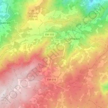
Name: Prados topographic map, elevation, terrain.
Location: Prados, Celorico da Beira, Guarda, Portugal (40.53734 -7.42789 40.57116 -7.35587)
Average elevation: 3,153 ft
Minimum elevation: 1,775 ft
Maximum elevation: 4,117 ft
Make a donation
Gear up for your next adventure:
As an Amazon Associate, this site earns from qualifying purchases at no extra cost to you.
Other topographic maps
Click on a map to view its topography, its elevation and its terrain.
Make a donation
Gear up for your next adventure:
As an Amazon Associate, this site earns from qualifying purchases at no extra cost to you.
Make a donation
Gear up for your next adventure:
As an Amazon Associate, this site earns from qualifying purchases at no extra cost to you.