
Thank you for supporting this site ❤️
Make a donation
Make a donation
Gear up for your next adventure:
As an Amazon Associate, this site earns from qualifying purchases at no extra cost to you.
Omaopio topographic map
Click on the map to display elevation.
Thank you for supporting this site ❤️
Make a donation
Make a donation
Gear up for your next adventure:
As an Amazon Associate, this site earns from qualifying purchases at no extra cost to you.
About this map
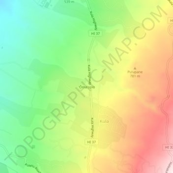
Name: Omaopio topographic map, elevation, terrain.
Location: Omaopio, Kula, Maui County, Hawaii, 96790, United States (20.78000 -156.34806 20.82000 -156.30806)
Average elevation: 2,185 ft
Minimum elevation: 1,312 ft
Maximum elevation: 3,261 ft
Maui County trails, hiking, mountain biking, running and outdoor activities
Thank you for supporting this site ❤️
Make a donation
Make a donation
Gear up for your next adventure:
As an Amazon Associate, this site earns from qualifying purchases at no extra cost to you.