Geolocate

Calitzdorp topographic map

Click on the map to display elevation.

About this map

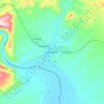
Name: Calitzdorp topographic map, elevation, terrain.

Location: Calitzdorp, George, Western Cape, 6660, South Africa (-33.57267 21.64786 -33.49267 21.72786)

Average elevation: 1,007 ft

Minimum elevation: 679 ft

Maximum elevation: 2,274 ft

Other topographic maps

Click on a map to view its topography, its elevation and its terrain.

Touwsranten

South Africa > Western Cape > George

Average elevation: 663 ft

Danabaai

South Africa > Western Cape > George

Average elevation: 358 ft

Oudtshoorn

South Africa > Western Cape > George

Average elevation: 1,158 ft

Oudtshoorn

South Africa > Western Cape > George

Average elevation: 1,158 ft

Friemersheim

South Africa > Western Cape > George

Average elevation: 860 ft

Oudtshoorn

South Africa > Western Cape > George

Average elevation: 1,158 ft

Garden Route Dam

South Africa > Western Cape > George

Average elevation: 656 ft

Gear up for your next adventure:

🧦Merino Wool Socks - Moisture-wicking, blister-preventing socks for long treks
🥄Camping Utensil Set - Lightweight utensils for outdoor meals
🧭Map Reading Tools - Tools and kits for map navigation
🔥Fast-Boil Camping Stoves - Efficient cooking systems for quick trail meals
🕶️Glacier Sunglasses - Side shields to protect eyes from high-altitude snow glare

As an Amazon Associate, this site earns from qualifying purchases at no extra cost to you.