
Make a donation
Gear up for your next adventure:
As an Amazon Associate, this site earns from qualifying purchases at no extra cost to you.
Monte-Estreino topographic map
Click on the map to display elevation.
Make a donation
Gear up for your next adventure:
As an Amazon Associate, this site earns from qualifying purchases at no extra cost to you.
About this map
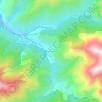
Name: Monte-Estreino topographic map, elevation, terrain.
Average elevation: 1,647 ft
Minimum elevation: 505 ft
Maximum elevation: 4,052 ft
Make a donation
Gear up for your next adventure:
As an Amazon Associate, this site earns from qualifying purchases at no extra cost to you.
Other topographic maps
Click on a map to view its topography, its elevation and its terrain.
Manso
France > Corse > Haute-Corse > Barghiana
Le Fango petit fleuve côtier prend sa source sur la commune, au pied du Capu Tafunatu à près de 2 000 m. Il porte alors le nom de ruisseau de Capu di Vetto. Il prend le nom de fleuve un kilomètre plus bas, à 1 049 m d'altitude. Son cours est de 24 kilomètres. De nombreuses "piscines naturelles" jalonnent…
Average elevation: 2,411 ft