
Thank you for supporting this site ❤️
Make a donation
Make a donation
Gear up for your next adventure:
As an Amazon Associate, this site earns from qualifying purchases at no extra cost to you.
Pepe topographic map
Click on the map to display elevation.
Thank you for supporting this site ❤️
Make a donation
Make a donation
Gear up for your next adventure:
As an Amazon Associate, this site earns from qualifying purchases at no extra cost to you.
About this map
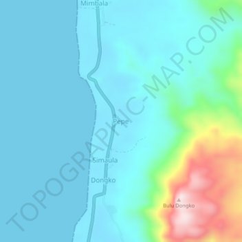
Name: Pepe topographic map, elevation, terrain.
Location: Pepe, Tolitoli, Central Sulawesi, Indonesia (0.81333 120.23000 0.85333 120.27000)
Average elevation: 243 ft
Minimum elevation: 0 ft
Maximum elevation: 1,476 ft
Thank you for supporting this site ❤️
Make a donation
Make a donation
Gear up for your next adventure:
As an Amazon Associate, this site earns from qualifying purchases at no extra cost to you.