
Thank you for supporting this site ❤️
Make a donation
Make a donation
Gear up for your next adventure:
As an Amazon Associate, this site earns from qualifying purchases at no extra cost to you.
Ponferrada topographic map
Click on the map to display elevation.
Thank you for supporting this site ❤️
Make a donation
Make a donation
Gear up for your next adventure:
As an Amazon Associate, this site earns from qualifying purchases at no extra cost to you.
About this map
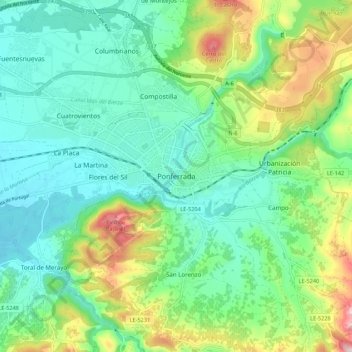
Name: Ponferrada topographic map, elevation, terrain.
Location: Ponferrada, El Bierzo, León, Castille-et-León, 24402, Espagne (42.50541 -6.63387 42.58541 -6.55387)
Average elevation: 1,916 ft
Minimum elevation: 1,562 ft
Maximum elevation: 2,812 ft
Thank you for supporting this site ❤️
Make a donation
Make a donation
Gear up for your next adventure:
As an Amazon Associate, this site earns from qualifying purchases at no extra cost to you.