
Make a donation
Gear up for your next adventure:
As an Amazon Associate, this site earns from qualifying purchases at no extra cost to you.
Harleshausen topographic map
Click on the map to display elevation.
Make a donation
Gear up for your next adventure:
As an Amazon Associate, this site earns from qualifying purchases at no extra cost to you.
About this map
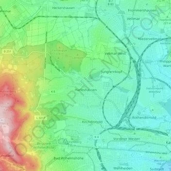
Name: Harleshausen topographic map, elevation, terrain.
Location: Harleshausen, Kassel, Hessen, 34128, Deutschland (51.31981 9.36906 51.35417 9.47249)
Average elevation: 814 ft
Minimum elevation: 453 ft
Maximum elevation: 1,841 ft
Make a donation
Gear up for your next adventure:
As an Amazon Associate, this site earns from qualifying purchases at no extra cost to you.
Other topographic maps
Click on a map to view its topography, its elevation and its terrain.
Karlsaue
Deutschland > Hessen > Kassel
In der Nähe des Sees steht eine Stieleiche mit einem Brusthöhenumfang von 7,95 m (2015).
Average elevation: 499 ft
Make a donation
Gear up for your next adventure:
As an Amazon Associate, this site earns from qualifying purchases at no extra cost to you.