
Thank you for supporting this site ❤️
Make a donation
Make a donation
Gear up for your next adventure:
As an Amazon Associate, this site earns from qualifying purchases at no extra cost to you.
Manzini topographic map
Click on the map to display elevation.
Thank you for supporting this site ❤️
Make a donation
Make a donation
Gear up for your next adventure:
As an Amazon Associate, this site earns from qualifying purchases at no extra cost to you.
About this map
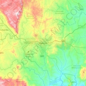
Name: Manzini topographic map, elevation, terrain.
Location: Manzini, Inkhundla Manzini, Manzini Region, M100, Eswatini (-26.65764 31.21508 -26.33764 31.53508)
Average elevation: 2,041 ft
Minimum elevation: 902 ft
Maximum elevation: 4,577 ft
Thank you for supporting this site ❤️
Make a donation
Make a donation
Gear up for your next adventure:
As an Amazon Associate, this site earns from qualifying purchases at no extra cost to you.