
Make a donation
Gear up for your next adventure:
As an Amazon Associate, this site earns from qualifying purchases at no extra cost to you.
Tecumseh topographic map
Click on the map to display elevation.
Make a donation
Gear up for your next adventure:
As an Amazon Associate, this site earns from qualifying purchases at no extra cost to you.
About this map
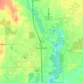
Name: Tecumseh topographic map, elevation, terrain.
Location: Tecumseh, Lenawee County, Michigan, 49286, United States (41.98898 -83.97463 42.02710 -83.90556)
Average elevation: 810 ft
Minimum elevation: 741 ft
Maximum elevation: 896 ft
Lenawee County trails, hiking, mountain biking, running and outdoor activities
Make a donation
Gear up for your next adventure:
As an Amazon Associate, this site earns from qualifying purchases at no extra cost to you.
Other topographic maps
Click on a map to view its topography, its elevation and its terrain.
do not know flow
United States > Michigan > Lenawee County > Cambridge Township > Oak Shade Park
Average elevation: 978 ft
Make a donation
Gear up for your next adventure:
As an Amazon Associate, this site earns from qualifying purchases at no extra cost to you.