
Make a donation
Gear up for your next adventure:
As an Amazon Associate, this site earns from qualifying purchases at no extra cost to you.
Al Ruwais topographic map
Click on the map to display elevation.
Make a donation
Gear up for your next adventure:
As an Amazon Associate, this site earns from qualifying purchases at no extra cost to you.
Al Ruwais
The area around Al Ruwais is generally characterized by a flat surface, lacking significant topographical complexities. This resembles much of the northern side of Qatar's coastal plain region, of which Al Ruwais is the northernmost extension. Between Al Jumail and Al Ruwais, the coastline features several indentations.
Make a donation
Gear up for your next adventure:
As an Amazon Associate, this site earns from qualifying purchases at no extra cost to you.
About this map
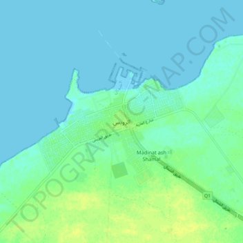
Name: Al Ruwais topographic map, elevation, terrain.
Location: Al Ruwais, Ash Shamal, Qatar (26.08950 51.16465 26.16950 51.24465)
Average elevation: 16 ft
Minimum elevation: -3 ft
Maximum elevation: 46 ft
Make a donation
Gear up for your next adventure:
As an Amazon Associate, this site earns from qualifying purchases at no extra cost to you.