Geolocate
👉 Easily get elevation data in JSON, GeoTIFF and KML formats using Elevation API
Thank you for supporting this site ❤️
Make a donation

Wood River topographic map

Click on the map to display elevation.

About this map

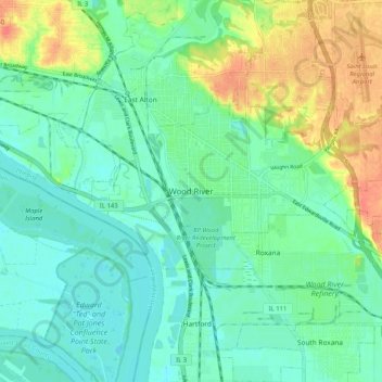
Name: Wood River topographic map, elevation, terrain.

Location: Wood River, Madison County, Illinois, 62095, United States (38.82116 -90.13761 38.90116 -90.05761)

Average elevation: 453 ft

Minimum elevation: 397 ft

Maximum elevation: 574 ft

Madison County trails, hiking, mountain biking, running and outdoor activities

Gear up for your next adventure:

🪶Wildlife Field Guides - Learn animal tracking and species ID
🔪Outdoor Multitools - Essential survival tools for gear repair and field use
Backpacking Tent - Lightweight and durable tent for multi‑day hikes
🚑Emergency Bivvies - Heat-reflective sleeping bags for survival situations
🪶Thermal Camp Blanket - Extra warmth for cold nights

As an Amazon Associate, this site earns from qualifying purchases at no extra cost to you.