Geolocate

Rayadurg topographic map

Click on the map to display elevation.

About this map

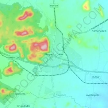
Name: Rayadurg topographic map, elevation, terrain.

Location: Rayadurg, Anantapur, Andhra Pradesh, 515865, India (14.66062 76.80951 14.74062 76.88951)

Average elevation: 1,893 ft

Minimum elevation: 1,693 ft

Maximum elevation: 2,661 ft

Gear up for your next adventure:

🚗GPS Dash Cams - Record your scenic drives through mountain passes and canyons
🧭Map Reading Tools - Tools and kits for map navigation
🧯Portable Fire Pit - Compact fire pit for camping spots
🚑Emergency Bivvies - Heat-reflective sleeping bags for survival situations
🎒Gear Packing Cubes - Organize your backpack efficiently

As an Amazon Associate, this site earns from qualifying purchases at no extra cost to you.