
Thank you for supporting this site ❤️
Make a donation
Make a donation
Gear up for your next adventure:
As an Amazon Associate, this site earns from qualifying purchases at no extra cost to you.
Zhijiang Dong Autonomous County topographic map
Click on the map to display elevation.
Thank you for supporting this site ❤️
Make a donation
Make a donation
Gear up for your next adventure:
As an Amazon Associate, this site earns from qualifying purchases at no extra cost to you.
About this map
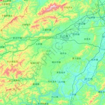
Name: Zhijiang Dong Autonomous County topographic map, elevation, terrain.
Location: Zhijiang Dong Autonomous County, Huaihua, Hunan, China (27.07002 109.28964 27.64127 109.90824)
Average elevation: 1,375 ft
Minimum elevation: 574 ft
Maximum elevation: 4,508 ft
Thank you for supporting this site ❤️
Make a donation
Make a donation
Gear up for your next adventure:
As an Amazon Associate, this site earns from qualifying purchases at no extra cost to you.