
Burr topographic map
Click on the map to display elevation.
About this map
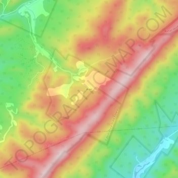
Name: Burr topographic map, elevation, terrain.
Location: Burr, Pocahontas County, West Virginia, United States (38.04568 -80.12507 38.08568 -80.08507)
Average elevation: 2,933 ft
Minimum elevation: 2,306 ft
Maximum elevation: 3,488 ft
Other topographic maps
Click on a map to view its topography, its elevation and its terrain.
Cranberry Wilderness
United States > West Virginia > Pocahontas County
The wilderness is located in the Yew Mountains, which are part of the Allegheny Mountains. The highest point in the wilderness is along Black Mountain at 4,556 feet (1,389 m), although there is a slightly higher point at 4,603 feet (1,403 m) just outside the wilderness. The lowest elevation in the wilderness…
Average elevation: 3,609 ft
Monongahela National Forest
United States > West Virginia > Pocahontas County
In 1943 and 1944, as part of the West Virginia Maneuver Area, the U.S. Army used parts of the Monongahela National Forest as a practice artillery and mortar range and maneuver area before troops were sent to Europe to fight in World War II. Artillery and mortar shells shot into the area for practice are still…
Average elevation: 2,149 ft
Green Bank Telescope
United States > West Virginia > Pocahontas County
As an azimuth-elevation mounting telescope, the azimuth adjustments are driven by four trucks with four wheels each on a 210-foot (64 m) diameter rail. The 16 thirty-horsepower motors can change azimuth at the rate of up to 40 degrees per minute. Azimuth axis is also supported by a pintle bearing at the center…
Average elevation: 2,697 ft