Geolocate

Fort Payne topographic map

Interactive map

Click on the map to display elevation.

About this map

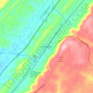
Name: Fort Payne topographic map, elevation, terrain.

Location: Fort Payne, DeKalb County, Alabama, 35967, United States (34.40425 -85.75969 34.48425 -85.67969)

Average elevation: 1,148 ft

Minimum elevation: 781 ft

Maximum elevation: 1,736 ft

Other topographic maps

Click on a map to view its topography, its elevation and its terrain.

Desoto State Park

United States > Alabama > DeKalb County > Fort Payne

Desoto State Park, Fort Payne, DeKalb County, Alabama, United States

Average elevation: 1,490 ft

Minvale

United States > Alabama > DeKalb County > Fort Payne > Minvale

Minvale, Fort Payne, DeKalb County, Alabama, 35967, United States

Average elevation: 1,056 ft

Little River Canyon National Preserve

United States > Alabama > DeKalb County > Fort Payne

Little River Canyon National Preserve, Fort Payne, DeKalb County, Alabama, United States

Average elevation: 1,076 ft