
Make a donation
Gear up for your next adventure:
As an Amazon Associate, this site earns from qualifying purchases at no extra cost to you.
Marienthal topographic map
Click on the map to display elevation.
Make a donation
Gear up for your next adventure:
As an Amazon Associate, this site earns from qualifying purchases at no extra cost to you.
Marienthal
Der Weinort Marienthal besitzt fünf Einzellagen. Es handelt sich durchweg um Steillagen mit Grauwackeverwitterungen im oberen Bereich und Löß und Lehm im unteren Abschnitt. Die erzeugten Weine fallen von den Trauben im oberen Bereich (um 200–250 m Höhe) fruchtig und von den Rebstöcken im unteren Abschnitt (um 100 m) füllig-kräftiger aus.
Make a donation
Gear up for your next adventure:
As an Amazon Associate, this site earns from qualifying purchases at no extra cost to you.
About this map
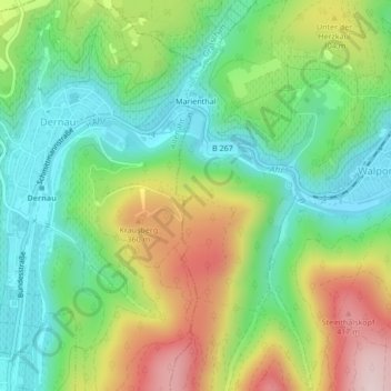
Name: Marienthal topographic map, elevation, terrain.
Average elevation: 761 ft
Minimum elevation: 354 ft
Maximum elevation: 1,447 ft
Make a donation
Gear up for your next adventure:
As an Amazon Associate, this site earns from qualifying purchases at no extra cost to you.