
Ashford topographic map
Click on the map to display elevation.
About this map
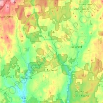
Name: Ashford topographic map, elevation, terrain.
Average elevation: 663 ft
Minimum elevation: 328 ft
Maximum elevation: 1,168 ft
Other topographic maps
Click on a map to view its topography, its elevation and its terrain.
Killingly Center
United States > Connecticut > Northeastern Connecticut Planning Region > Killingly > Dayville
Average elevation: 358 ft
Central Village
United States > Connecticut > Northeastern Connecticut Planning Region > Plainfield
Average elevation: 226 ft
Sky Hill
United States > Connecticut > Northeastern Connecticut Planning Region > Ashford
Average elevation: 971 ft
Elmville
United States > Connecticut > Northeastern Connecticut Planning Region > Killingly
Average elevation: 348 ft