
Make a donation
Gear up for your next adventure:
As an Amazon Associate, this site earns from qualifying purchases at no extra cost to you.
Apía topographic map
Click on the map to display elevation.
Make a donation
Gear up for your next adventure:
As an Amazon Associate, this site earns from qualifying purchases at no extra cost to you.
Apía
Apía is a town and municipality in the Department of Risaralda, Colombia. It is located at an elevation of 1,630 metres, about 60 km away from district capital Pereira in the valley of the Apia river. It has approximately 11,000 inhabitants according to the 2018 census. The town has excellent views over the Tatamá Hill which is part of the Tatamá Nature Park.
Make a donation
Gear up for your next adventure:
As an Amazon Associate, this site earns from qualifying purchases at no extra cost to you.
About this map
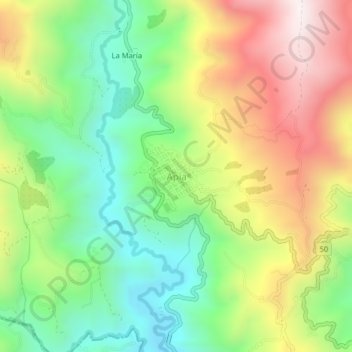
Name: Apía topographic map, elevation, terrain.
Location: Apía, Vertiente Occidental, Risaralda, Colombia (5.08655 -75.96250 5.12655 -75.92250)
Average elevation: 5,400 ft
Minimum elevation: 4,173 ft
Maximum elevation: 7,077 ft
Make a donation
Gear up for your next adventure:
As an Amazon Associate, this site earns from qualifying purchases at no extra cost to you.