Geolocate

Dyer topographic map

Click on the map to display elevation.

About this map

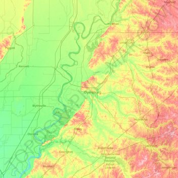
Name: Dyer topographic map, elevation, terrain.

Location: Dyer, Tennessee, 38024, United States (35.35433 -90.12082 36.75433 -88.72082)

Average elevation: 328 ft

Minimum elevation: 190 ft

Maximum elevation: 640 ft

Dyer trails, hiking, mountain biking, running and outdoor activities

Gear up for your next adventure:

🛡️Bear Spray Outdoor - Protection in bear country hikes
🥤Water Filter Bottle - All‑in‑one filter bottle for safe hydration
🌧️Backpack Rain Cover - Keep gear dry in wet weather
🔭Stargazing Telescopes - Perfect for camping in low-light pollution areas shown on maps
🥾Men's Hiking Boots - Durable, waterproof footwear for rugged terrain and steep inclines

As an Amazon Associate, this site earns from qualifying purchases at no extra cost to you.