
Make a donation
Gear up for your next adventure:
As an Amazon Associate, this site earns from qualifying purchases at no extra cost to you.
Schönwalde topographic map
Click on the map to display elevation.
Make a donation
Gear up for your next adventure:
As an Amazon Associate, this site earns from qualifying purchases at no extra cost to you.
Schönwalde
Schönwalde befindet sich auf dem westlichen Teil der Barnim-Hochfläche, dem sogenannten Niederbarnim. Die Höhe über Normalhöhennull (NHN) nimmt von Ost nach West leicht ab. Höchster Punkt mit 69,6 Meter über NHN ist die nordöstliche Ortsteilgrenze zu Bernau in der Bernauer Heide. Mit 44,5 Meter über NHN ist die Fläche des Mühlenbecker Sees an der Westgrenze der niedrigste Punkt des Ortes. Die Höhe der Ortsmitte an der Kirche beträgt 57 Meter, die des zwei Kilometer östlich von dieser gelegenen Gorinsees 58,5 Meter über NHN.
Make a donation
Gear up for your next adventure:
As an Amazon Associate, this site earns from qualifying purchases at no extra cost to you.
About this map
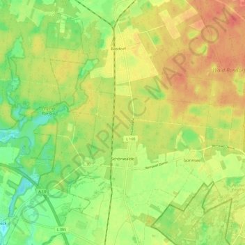
Name: Schönwalde topographic map, elevation, terrain.
Location: Schönwalde, Wandlitz, Barnim, Brandenburg, Deutschland (52.66712 13.39528 52.71683 13.50860)
Average elevation: 200 ft
Minimum elevation: 118 ft
Maximum elevation: 269 ft
Make a donation
Gear up for your next adventure:
As an Amazon Associate, this site earns from qualifying purchases at no extra cost to you.