Geolocate

Anapoima topographic map

Click on the map to display elevation.

About this map

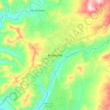
Name: Anapoima topographic map, elevation, terrain.

Location: Anapoima, Tequendama, Cundinamarca, Colombia (4.50930 -74.57591 4.58930 -74.49591)

Average elevation: 2,231 ft

Minimum elevation: 1,430 ft

Maximum elevation: 3,537 ft

Gear up for your next adventure:

🪶Multi‑Purpose Knife - Useful blade for camp and trail
🧭Map Reading Tools - Tools and kits for map navigation
🧥Men's Rain Shells - Premium waterproof and breathable jackets for mountain weather
🔊Portable Camp Speaker - Music and alerts at camp
🔥Camping Stove - Portable stove for camping and backcountry cooking

As an Amazon Associate, this site earns from qualifying purchases at no extra cost to you.