
Thank you for supporting this site ❤️
Make a donation
Make a donation
Gear up for your next adventure:
As an Amazon Associate, this site earns from qualifying purchases at no extra cost to you.
Gavà topographic map
Click on the map to display elevation.
Thank you for supporting this site ❤️
Make a donation
Make a donation
Gear up for your next adventure:
As an Amazon Associate, this site earns from qualifying purchases at no extra cost to you.
About this map
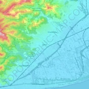
Name: Gavà topographic map, elevation, terrain.
Location: Gavà, Bajo Llobregat, Barcelona, Cataluña, 08850, España (41.26509 1.96631 41.34509 2.04631)
Average elevation: 200 ft
Minimum elevation: -3 ft
Maximum elevation: 1,286 ft
Thank you for supporting this site ❤️
Make a donation
Make a donation
Gear up for your next adventure:
As an Amazon Associate, this site earns from qualifying purchases at no extra cost to you.