
Thank you for supporting this site ❤️
Make a donation
Make a donation
Gear up for your next adventure:
As an Amazon Associate, this site earns from qualifying purchases at no extra cost to you.
Ava topographic map
Click on the map to display elevation.
Thank you for supporting this site ❤️
Make a donation
Make a donation
Gear up for your next adventure:
As an Amazon Associate, this site earns from qualifying purchases at no extra cost to you.
About this map
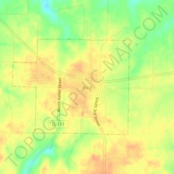
Name: Ava topographic map, elevation, terrain.
Location: Ava, Jackson County, Illinois, United States (37.88103 -89.50954 37.89586 -89.48654)
Average elevation: 581 ft
Minimum elevation: 505 ft
Maximum elevation: 623 ft
Jackson County trails, hiking, mountain biking, running and outdoor activities
Thank you for supporting this site ❤️
Make a donation
Make a donation
Gear up for your next adventure:
As an Amazon Associate, this site earns from qualifying purchases at no extra cost to you.
Other topographic maps
Click on a map to view its topography, its elevation and its terrain.
Lake Shore Drive Area
United States > Illinois > Jackson County > Carbondale
Average elevation: 440 ft