
Make a donation
Gear up for your next adventure:
As an Amazon Associate, this site earns from qualifying purchases at no extra cost to you.
Petacas topographic map
Click on the map to display elevation.
Make a donation
Gear up for your next adventure:
As an Amazon Associate, this site earns from qualifying purchases at no extra cost to you.
About this map
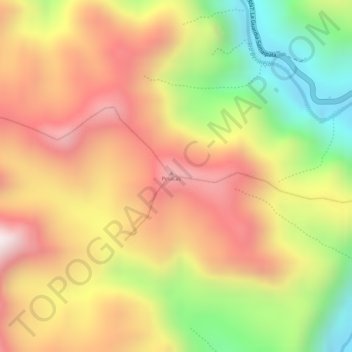
Name: Petacas topographic map, elevation, terrain.
Average elevation: 3,684 ft
Minimum elevation: 2,359 ft
Maximum elevation: 4,685 ft
Make a donation
Gear up for your next adventure:
As an Amazon Associate, this site earns from qualifying purchases at no extra cost to you.
Other topographic maps
Click on a map to view its topography, its elevation and its terrain.
Samaipata
Bolivia > Santa Cruz > Provincia Florida > Municipio Samaipata
Samaipata or Samaypata (Quechua samay to rest, pata elevated place / above, at the top / edge, bank (of a river), shore) is a small town in the Florida Province of the Santa Cruz Department in Bolivia. It has a subtropical climate and an altitude of 1600–1800 m. It lies about 120 kilometers to the southwest…
Average elevation: 5,561 ft