Geolocate

Calumpang topographic map

Click on the map to display elevation.

About this map

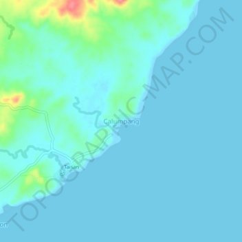
Name: Calumpang topographic map, elevation, terrain.

Location: Calumpang, Bangad, Masbate, Bicol Region, Philippines (12.09153 123.34908 12.13153 123.38908)

Average elevation: 33 ft

Minimum elevation: 0 ft

Maximum elevation: 266 ft

Gear up for your next adventure:

🪶Paracord Bracelet - Survival bracelet with built‑in tools
🌲Outdoor Survival Books - Best books on survival skills
🎒Trail Energy Bars - High‑calorie bars for hiking energy
Backpacking Tent - Lightweight and durable tent for multi‑day hikes
🪵Folding Camp Saw - Compact saw for wood and campsite work

As an Amazon Associate, this site earns from qualifying purchases at no extra cost to you.