Geolocate

Yebra de Basa topographic map

Click on the map to display elevation.

About this map

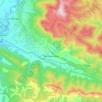
Name: Yebra de Basa topographic map, elevation, terrain.

Location: Yebra de Basa, Alto Gállego, Huesca, Aragon, Spain (42.43728 -0.31314 42.54641 -0.17469)

Average elevation: 3,802 ft

Minimum elevation: 2,507 ft

Maximum elevation: 6,276 ft

Gear up for your next adventure:

🗺️Topographic Maps - Detailed topo maps for hiking, exploring and outdoor navigation
📌Outdoor GPS Map App - Apps and devices for digital topographic navigation
🧭Outdoor Navigation Book - Learn advanced navigation skills
🗺️NatGeo Topo Maps - High-quality waterproof printed topographic maps of US Parks
🔥Plasma Lighters - Windproof lighters that work in any weather condition

As an Amazon Associate, this site earns from qualifying purchases at no extra cost to you.