
Make a donation
Gear up for your next adventure:
As an Amazon Associate, this site earns from qualifying purchases at no extra cost to you.
Congoberg topographic map
Click on the map to display elevation.
Make a donation
Gear up for your next adventure:
As an Amazon Associate, this site earns from qualifying purchases at no extra cost to you.
Congoberg
Op 31 januari 2021 was op de VRT te zien hoe Tom Waes tijdens zijn reis door Vlaanderen in Vlaams-Brabant was, met zanger en kunstenaar Herman Dewit, maakte hij een kunstwerk ter hoogte van de Congoberg. Tom Waes moest noodgedwongen thuis blijven en hij ging voor Reizen Waes dan maar in elke Vlaamse provincie een reportage draaien, op de leukste en mooiste plekjes waaronder de Congoberg in het Pajottenland.
Make a donation
Gear up for your next adventure:
As an Amazon Associate, this site earns from qualifying purchases at no extra cost to you.
About this map
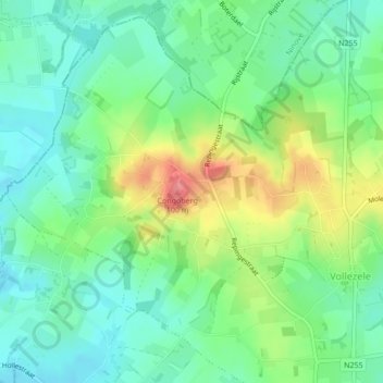
Name: Congoberg topographic map, elevation, terrain.
Average elevation: 174 ft
Minimum elevation: 82 ft
Maximum elevation: 344 ft
Make a donation
Gear up for your next adventure:
As an Amazon Associate, this site earns from qualifying purchases at no extra cost to you.
Other topographic maps
Click on a map to view its topography, its elevation and its terrain.
Kluysbos
België > Vlaams-Brabant > Halle-Vilvoorde > Galmaarden > Sint-Paulus
Average elevation: 161 ft