
Make a donation
Gear up for your next adventure:
As an Amazon Associate, this site earns from qualifying purchases at no extra cost to you.
Degersee topographic map
Click on the map to display elevation.
Make a donation
Gear up for your next adventure:
As an Amazon Associate, this site earns from qualifying purchases at no extra cost to you.
Degersee
Der Degersee gehört größtenteils zum Gebiet der Stadt Tettnang im Bodenseekreis. Ein kleiner Bereich im Südosten gehört zur bayerischen Stadt Lindau. Der See liegt im hügeligen, vielfach von Obstanbau geprägten Hinterland des Bodensees auf einer Höhe von 478,2 m ü. NHN. Die Größe des Sees beträgt 30 Hektar, seine Uferlänge etwa 2730 Meter. Mit einer durchschnittlichen Tiefe von rund sechs Metern und einer maximalen Tiefe von elf Metern ergibt sich ein Seevolumen von rund 1,828 Millionen Kubikmetern.
Make a donation
Gear up for your next adventure:
As an Amazon Associate, this site earns from qualifying purchases at no extra cost to you.
About this map
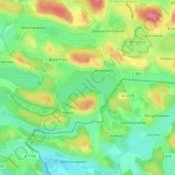
Name: Degersee topographic map, elevation, terrain.
Average elevation: 1,601 ft
Minimum elevation: 1,473 ft
Maximum elevation: 1,785 ft
Make a donation
Gear up for your next adventure:
As an Amazon Associate, this site earns from qualifying purchases at no extra cost to you.