
Thank you for supporting this site ❤️
Make a donation
Make a donation
Gear up for your next adventure:
As an Amazon Associate, this site earns from qualifying purchases at no extra cost to you.
Orrit topographic map
Click on the map to display elevation.
Thank you for supporting this site ❤️
Make a donation
Make a donation
Gear up for your next adventure:
As an Amazon Associate, this site earns from qualifying purchases at no extra cost to you.
About this map
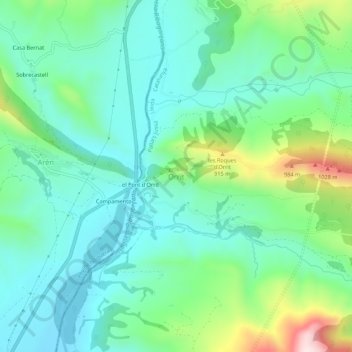
Name: Orrit topographic map, elevation, terrain.
Location: Orrit, Tremp, Pallars Jussà, Lerida, Catalonië, 22583, Spanje (42.23636 0.72168 42.27636 0.76168)
Average elevation: 2,392 ft
Minimum elevation: 1,978 ft
Maximum elevation: 3,606 ft
Thank you for supporting this site ❤️
Make a donation
Make a donation
Gear up for your next adventure:
As an Amazon Associate, this site earns from qualifying purchases at no extra cost to you.