
Make a donation
Gear up for your next adventure:
As an Amazon Associate, this site earns from qualifying purchases at no extra cost to you.
La Hulpe topographic map
Click on the map to display elevation.
Make a donation
Gear up for your next adventure:
As an Amazon Associate, this site earns from qualifying purchases at no extra cost to you.
About this map
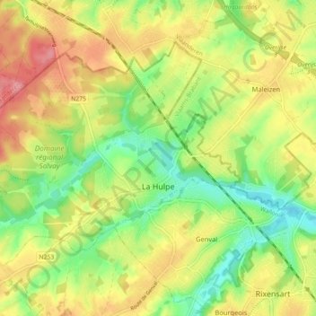
Name: La Hulpe topographic map, elevation, terrain.
Location: La Hulpe, Nivelles, Walloon Brabant, Wallonia, 1310, Belgium (50.71568 4.42389 50.75707 4.51255)
Average elevation: 295 ft
Minimum elevation: 151 ft
Maximum elevation: 449 ft
Make a donation
Gear up for your next adventure:
As an Amazon Associate, this site earns from qualifying purchases at no extra cost to you.
Other topographic maps
Click on a map to view its topography, its elevation and its terrain.
Quatre-Bras de Baisy-Thy
Belgium > Walloon Brabant > Nivelles > Genappe > Baisy-Thy > Quatre-Bras de Baisy-Thy
Average elevation: 479 ft
Make a donation
Gear up for your next adventure:
As an Amazon Associate, this site earns from qualifying purchases at no extra cost to you.