
Thank you for supporting this site ❤️
Make a donation
Make a donation
Gear up for your next adventure:
As an Amazon Associate, this site earns from qualifying purchases at no extra cost to you.
Settevene topographic map
Click on the map to display elevation.
Thank you for supporting this site ❤️
Make a donation
Make a donation
Gear up for your next adventure:
As an Amazon Associate, this site earns from qualifying purchases at no extra cost to you.
About this map
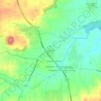
Name: Settevene topographic map, elevation, terrain.
Location: Settevene, Nepi, Viterbo, Lazio, 00063, Italia (42.14153 12.32002 42.18153 12.36002)
Average elevation: 715 ft
Minimum elevation: 568 ft
Maximum elevation: 978 ft
Thank you for supporting this site ❤️
Make a donation
Make a donation
Gear up for your next adventure:
As an Amazon Associate, this site earns from qualifying purchases at no extra cost to you.