
Thank you for supporting this site ❤️
Make a donation
Make a donation
Gear up for your next adventure:
As an Amazon Associate, this site earns from qualifying purchases at no extra cost to you.
Xhoffraix topographic map
Click on the map to display elevation.
Thank you for supporting this site ❤️
Make a donation
Make a donation
Gear up for your next adventure:
As an Amazon Associate, this site earns from qualifying purchases at no extra cost to you.
About this map
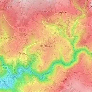
Name: Xhoffraix topographic map, elevation, terrain.
Location: Xhoffraix, Malmedy, Verviers, Liège, Wallonia, 4960, Belgium (50.43667 6.05020 50.47667 6.09020)
Average elevation: 1,663 ft
Minimum elevation: 1,129 ft
Maximum elevation: 1,985 ft
Thank you for supporting this site ❤️
Make a donation
Make a donation
Gear up for your next adventure:
As an Amazon Associate, this site earns from qualifying purchases at no extra cost to you.
Other topographic maps
Click on a map to view its topography, its elevation and its terrain.