Geolocate

Cedar Rapids topographic map

Click on the map to display elevation.

About this map

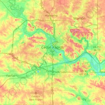
Name: Cedar Rapids topographic map, elevation, terrain.

Location: Cedar Rapids, Linn County, Iowa, United States (41.86160 -91.77458 42.07667 -91.55106)

Average elevation: 804 ft

Minimum elevation: 682 ft

Maximum elevation: 938 ft

Linn County trails, hiking, mountain biking, running and outdoor activities

Other topographic maps

Click on a map to view its topography, its elevation and its terrain.

New Buffalo

United States > Iowa > Linn County > Cedar Rapids

Average elevation: 830 ft

Lindale Manor

United States > Iowa > Linn County > Marion

Average elevation: 827 ft

Covington

United States > Iowa > Linn County

Average elevation: 784 ft

Paris

United States > Iowa > Linn County

Average elevation: 883 ft

Gear up for your next adventure:

🖼️Topo Map Wall Art - Decorative topographic prints of famous peaks and regions
🏔️Mountain Trail Maps - High‑detail maps for popular peaks
🎒Trekking Poles - Sturdy poles for balance and stability on rough terrain
Backpacking Tent - Lightweight and durable tent for multi‑day hikes
🧦Merino Wool Socks - Moisture-wicking, blister-preventing socks for long treks

As an Amazon Associate, this site earns from qualifying purchases at no extra cost to you.