Geolocate

Feuchtwangen topographic map

Click on the map to display elevation.

About this map

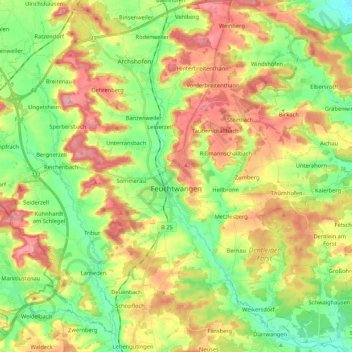
Name: Feuchtwangen topographic map, elevation, terrain.

Location: Feuchtwangen, Ansbach (district), Bavaria, 91555, Germany (49.10706 10.22949 49.23827 10.44162)

Average elevation: 1,558 ft

Minimum elevation: 1,398 ft

Maximum elevation: 1,755 ft

Other topographic maps

Click on a map to view its topography, its elevation and its terrain.

Waldhäuslein

Germany > Bavaria > Ansbach (district)

Average elevation: 1,552 ft

Gear up for your next adventure:

🛡️Insect Repellent - Protection against bugs during outdoor activities
🪄Magnetic Compass - Accurate compass for navigation
🚪Portable Camp Chair - Foldable chair for comfort at camp
🪶Survival Guide Book - Expert advice for emergency preparedness
🔌USB Car Charger - Car charger for on‑the‑go power needs

As an Amazon Associate, this site earns from qualifying purchases at no extra cost to you.