
Thank you for supporting this site ❤️
Make a donation
Make a donation
Gear up for your next adventure:
As an Amazon Associate, this site earns from qualifying purchases at no extra cost to you.
Lar topographic map
Click on the map to display elevation.
Thank you for supporting this site ❤️
Make a donation
Make a donation
Gear up for your next adventure:
As an Amazon Associate, this site earns from qualifying purchases at no extra cost to you.
About this map
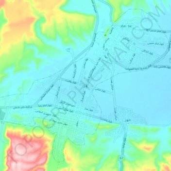
Name: Lar topographic map, elevation, terrain.
Location: Lar, بخش مرکزی, Larestan County, Fars Province, Iran (27.62594 54.27735 27.69789 54.36790)
Average elevation: 2,831 ft
Minimum elevation: 2,631 ft
Maximum elevation: 3,658 ft
Thank you for supporting this site ❤️
Make a donation
Make a donation
Gear up for your next adventure:
As an Amazon Associate, this site earns from qualifying purchases at no extra cost to you.