
Make a donation
Gear up for your next adventure:
As an Amazon Associate, this site earns from qualifying purchases at no extra cost to you.
Wankaner topographic map
Click on the map to display elevation.
Make a donation
Gear up for your next adventure:
As an Amazon Associate, this site earns from qualifying purchases at no extra cost to you.
Wankaner
Wankaner is located at 22°36′58″N 70°57′11″E / 22.61611°N 70.95306°E / 22.61611; 70.95306. It has an average elevation of 81 metres (265 feet) and is about 53 kilometres (33 mi) from Rajkot.
Make a donation
Gear up for your next adventure:
As an Amazon Associate, this site earns from qualifying purchases at no extra cost to you.
About this map
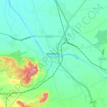
Name: Wankaner topographic map, elevation, terrain.
Location: Wankaner, Wankaner Taluka, Morbi, Gujarat, 363621, India (22.57539 70.90956 22.65539 70.98956)
Average elevation: 302 ft
Minimum elevation: 210 ft
Maximum elevation: 604 ft
Make a donation
Gear up for your next adventure:
As an Amazon Associate, this site earns from qualifying purchases at no extra cost to you.