
Thank you for supporting this site ❤️
Make a donation
Make a donation
Gear up for your next adventure:
As an Amazon Associate, this site earns from qualifying purchases at no extra cost to you.
Mühltal topographic map
Click on the map to display elevation.
Thank you for supporting this site ❤️
Make a donation
Make a donation
Gear up for your next adventure:
As an Amazon Associate, this site earns from qualifying purchases at no extra cost to you.
About this map
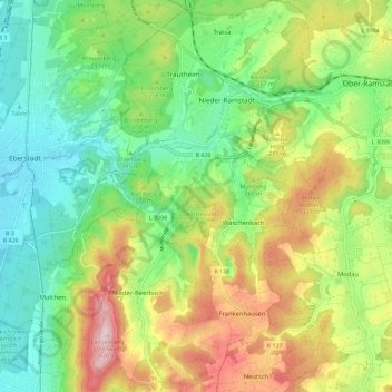
Name: Mühltal topographic map, elevation, terrain.
Location: Mühltal, Landkreis Darmstadt-Dieburg, Hesse, 64367, Germany (49.77240 8.65647 49.84669 8.72663)
Average elevation: 764 ft
Minimum elevation: 374 ft
Maximum elevation: 1,404 ft
Thank you for supporting this site ❤️
Make a donation
Make a donation
Gear up for your next adventure:
As an Amazon Associate, this site earns from qualifying purchases at no extra cost to you.