
Make a donation
Gear up for your next adventure:
As an Amazon Associate, this site earns from qualifying purchases at no extra cost to you.
Frankfurt (Oder) topographic map
Click on the map to display elevation.
Make a donation
Gear up for your next adventure:
As an Amazon Associate, this site earns from qualifying purchases at no extra cost to you.
About this map
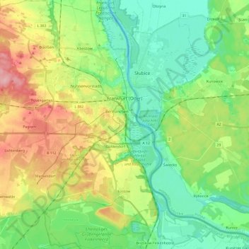
Name: Frankfurt (Oder) topographic map, elevation, terrain.
Location: Frankfurt (Oder), Brandenburg, Germany (52.25287 14.39483 52.39807 14.60136)
Average elevation: 177 ft
Minimum elevation: 26 ft
Maximum elevation: 453 ft
Make a donation
Gear up for your next adventure:
As an Amazon Associate, this site earns from qualifying purchases at no extra cost to you.
Other topographic maps
Click on a map to view its topography, its elevation and its terrain.
Battle of the Seelow Heights
Germany > Brandenburg > Märkisch-Oderland > Seelow
Average elevation: 72 ft
Make a donation
Gear up for your next adventure:
As an Amazon Associate, this site earns from qualifying purchases at no extra cost to you.