Geolocate

Bugujju topographic map

Click on the map to display elevation.

About this map

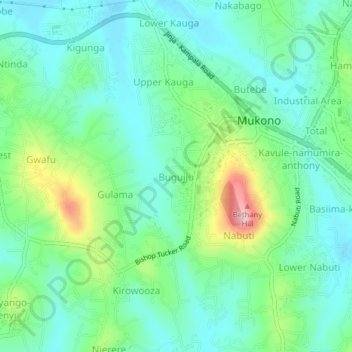
Name: Bugujju topographic map, elevation, terrain.

Location: Bugujju, Mukono, Central Region, Uganda (0.33453 32.71666 0.37453 32.75666)

Average elevation: 3,940 ft

Minimum elevation: 3,776 ft

Maximum elevation: 4,380 ft

Gear up for your next adventure:

📚Navigation Handbooks - Master the art of reading topographic maps and using a compass
🪶Camping Sleeping Pad - Comfortable sleeping pad for backpacking
🪶Paracord Bracelet - Survival bracelet with built‑in tools
🛡️Insect Repellent - Protection against bugs during outdoor activities
🏔️Mountain Trail Maps - High‑detail maps for popular peaks

As an Amazon Associate, this site earns from qualifying purchases at no extra cost to you.