
Make a donation
Gear up for your next adventure:
As an Amazon Associate, this site earns from qualifying purchases at no extra cost to you.
Paonta Sahib topographic map
Click on the map to display elevation.
Make a donation
Gear up for your next adventure:
As an Amazon Associate, this site earns from qualifying purchases at no extra cost to you.
Paonta Sahib
Paonta Sahib is located at 30°26′17″N 77°37′26″E / 30.438°N 77.624°E / 30.438; 77.624. It has an average elevation of 389 metres (1,276 feet). It is on the bank of the river Yamuna, the river being the boundary between the states of Himachal Pradesh and Uttarakhand. It is situated near the towns of Nahan in Himachal Pradesh, Yamunanagar in Haryana, Saharanpur in Western Uttar Pradesh and Dehradun in Uttarakhand. It is on the western extreme of the Doon Valley, which is at a distance of about 44 km from Dehradun. Kalesar National Park is 12 km from Paonta Sahib. Colonel Sher Jung National Park is around 7 km from the main town. Some luxury hotels to stay in Paonta Sahib are Hotel Guru Surbhi, Hotel Yamuna, and Hotel Paonta Valley.
Make a donation
Gear up for your next adventure:
As an Amazon Associate, this site earns from qualifying purchases at no extra cost to you.
About this map
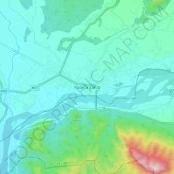
Name: Paonta Sahib topographic map, elevation, terrain.
Average elevation: 1,453 ft
Minimum elevation: 1,168 ft
Maximum elevation: 2,835 ft
Make a donation
Gear up for your next adventure:
As an Amazon Associate, this site earns from qualifying purchases at no extra cost to you.