
Thank you for supporting this site ❤️
Make a donation
Make a donation
Gear up for your next adventure:
As an Amazon Associate, this site earns from qualifying purchases at no extra cost to you.
San Martin topographic map
Click on the map to display elevation.
Thank you for supporting this site ❤️
Make a donation
Make a donation
Gear up for your next adventure:
As an Amazon Associate, this site earns from qualifying purchases at no extra cost to you.
About this map
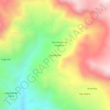
Name: San Martin topographic map, elevation, terrain.
Location: San Martin, Distrito de Ayabaca, Ayabaca, Piura, Perú (-4.72694 -79.55091 -4.68694 -79.51091)
Average elevation: 7,530 ft
Minimum elevation: 5,942 ft
Maximum elevation: 9,209 ft
Thank you for supporting this site ❤️
Make a donation
Make a donation
Gear up for your next adventure:
As an Amazon Associate, this site earns from qualifying purchases at no extra cost to you.
Other topographic maps
Click on a map to view its topography, its elevation and its terrain.
Área de Conservación Privada Lagunas y Páramos de Andinos de San José de Tapal
Perú > Piura > Distrito de Ayabaca
Average elevation: 11,001 ft