Geolocate

Tsagveri topographic map

Click on the map to display elevation.

About this map

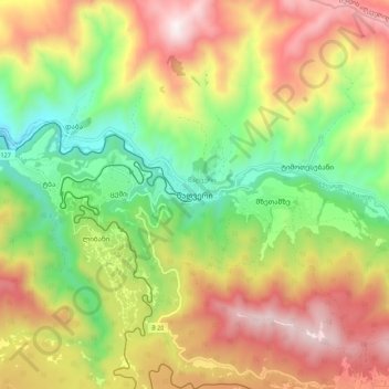
Name: Tsagveri topographic map, elevation, terrain.

Location: Tsagveri, Borjomi Municipality, Samtskhe-Javakheti, Georgia (41.75862 43.44323 41.83862 43.52323)

Average elevation: 4,659 ft

Minimum elevation: 3,018 ft

Maximum elevation: 6,549 ft

Other topographic maps

Click on a map to view its topography, its elevation and its terrain.

Borjomi

Georgia > Samtskhe-Javakheti > Borjomi Municipality

Average elevation: 3,182 ft

Gear up for your next adventure:

🌡️Handheld Weather Meters - Measure wind, temp, and pressure for safe mountain travel
📻Weather Alert Radios - Stay informed of storm risks while off-the-grid
🔋Rechargeable Batteries - Power up your outdoor devices
🔌Solar Panel Charger - Charge gear sustainably outdoors
Solar GPS Watches - Advanced multisport watches with built-in topographic maps

As an Amazon Associate, this site earns from qualifying purchases at no extra cost to you.