
Make a donation
Gear up for your next adventure:
As an Amazon Associate, this site earns from qualifying purchases at no extra cost to you.
Tlaxcala City topographic map
Click on the map to display elevation.
Make a donation
Gear up for your next adventure:
As an Amazon Associate, this site earns from qualifying purchases at no extra cost to you.
Tlaxcala City
The city is located in the central Mexican highlands 2,239 metres (7,346 feet) above sea level, in a valley of the same name, from which the Popocatépetl and Iztaccíhuatl volcanoes can be seen in the distance. The main elevations in the municipality are El Cerro Ostol at 2,460 metres (8,070 feet) and El Cerro Tepepan at 2,320 metres (7,610 feet).
Make a donation
Gear up for your next adventure:
As an Amazon Associate, this site earns from qualifying purchases at no extra cost to you.
About this map
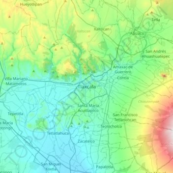
Name: Tlaxcala City topographic map, elevation, terrain.
Average elevation: 7,920 ft
Minimum elevation: 7,146 ft
Maximum elevation: 10,719 ft
Make a donation
Gear up for your next adventure:
As an Amazon Associate, this site earns from qualifying purchases at no extra cost to you.
Other topographic maps
Click on a map to view its topography, its elevation and its terrain.
Tlaxcala de Xicohténcatl
Mexico > Tlaxcala > Municipio de Tlaxcala
The city is located in the central Mexican highlands 2,239 metres (7,346 feet) above sea level, in a valley of the same name, from which the Popocatépetl and Iztaccíhuatl volcanoes can be seen in the distance. The main elevations in the municipality are El Cerro Ostol at 2,460 metres (8,070 feet) and El…
Average elevation: 7,441 ft