
Make a donation
Gear up for your next adventure:
As an Amazon Associate, this site earns from qualifying purchases at no extra cost to you.
Le Thoureil topographic map
Click on the map to display elevation.
Make a donation
Gear up for your next adventure:
As an Amazon Associate, this site earns from qualifying purchases at no extra cost to you.
About this map
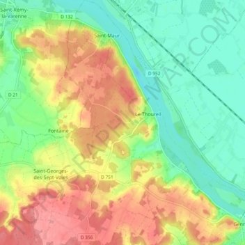
Name: Le Thoureil topographic map, elevation, terrain.
Average elevation: 151 ft
Minimum elevation: 33 ft
Maximum elevation: 299 ft
Make a donation
Gear up for your next adventure:
As an Amazon Associate, this site earns from qualifying purchases at no extra cost to you.
Other topographic maps
Click on a map to view its topography, its elevation and its terrain.
Le Moulin de l'Homme
France > Pays de la Loire > Maine-et-Loire > Gennes-Val-de-Loire
Average elevation: 190 ft
Île de Gennes-Sud
France > Pays de la Loire > Maine-et-Loire > Gennes-Val-de-Loire
Average elevation: 118 ft
Le Champ Logeais
France > Pays de la Loire > Maine-et-Loire > Gennes-Val-de-Loire
Average elevation: 210 ft
Étang de Joreau
France > Pays de la Loire > Maine-et-Loire > Gennes-Val-de-Loire
Average elevation: 226 ft
Make a donation
Gear up for your next adventure:
As an Amazon Associate, this site earns from qualifying purchases at no extra cost to you.
Le Gué de Fresne
France > Pays de la Loire > Maine-et-Loire > Gennes-Val-de-Loire
Average elevation: 75 ft
Saint-Florent
France > Pays de la Loire > Maine-et-Loire > Gennes-Val-de-Loire > Le Grand Chemin
Average elevation: 69 ft
Make a donation
Gear up for your next adventure:
As an Amazon Associate, this site earns from qualifying purchases at no extra cost to you.
Château de Boumois
France > Pays de la Loire > Maine-et-Loire > Gennes-Val-de-Loire
Average elevation: 89 ft
Île de Trèves
France > Pays de la Loire > Maine-et-Loire > Gennes-Val-de-Loire > Île de Trèves
Average elevation: 125 ft
Réserve naturelle des étang et boisements de Joreau
France > Pays de la Loire > Maine-et-Loire > Gennes-Val-de-Loire
Average elevation: 217 ft
Make a donation
Gear up for your next adventure:
As an Amazon Associate, this site earns from qualifying purchases at no extra cost to you.
Le Moulin Gasté
France > Pays de la Loire > Maine-et-Loire > Gennes-Val-de-Loire
Average elevation: 200 ft
Pierre Longue du Bouchet
France > Pays de la Loire > Maine-et-Loire > Gennes-Val-de-Loire
Average elevation: 207 ft
Make a donation
Gear up for your next adventure:
As an Amazon Associate, this site earns from qualifying purchases at no extra cost to you.
Île du Buisson
France > Pays de la Loire > Maine-et-Loire > Gennes-Val-de-Loire
Average elevation: 131 ft