
Thank you for supporting this site ❤️
Make a donation
Make a donation
Gear up for your next adventure:
As an Amazon Associate, this site earns from qualifying purchases at no extra cost to you.
Werft topographic map
Click on the map to display elevation.
Thank you for supporting this site ❤️
Make a donation
Make a donation
Gear up for your next adventure:
As an Amazon Associate, this site earns from qualifying purchases at no extra cost to you.
About this map
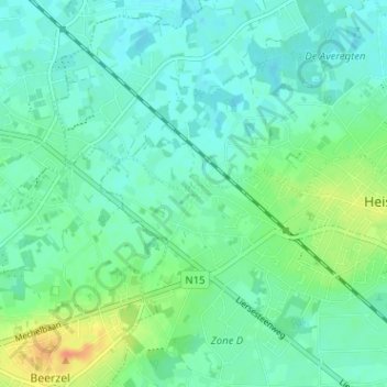
Name: Werft topographic map, elevation, terrain.
Average elevation: 49 ft
Minimum elevation: 16 ft
Maximum elevation: 138 ft
Thank you for supporting this site ❤️
Make a donation
Make a donation
Gear up for your next adventure:
As an Amazon Associate, this site earns from qualifying purchases at no extra cost to you.
Other topographic maps
Click on a map to view its topography, its elevation and its terrain.
Itegem
België > Antwerpen > Mechelen > Heist-op-den-Berg
Itegem ligt in de Kempen nabij de vallei van de Grote Nete op een hoogte van ongeveer 10 meter.
Average elevation: 33 ft