
Thank you for supporting this site ❤️
Make a donation
Make a donation
Gear up for your next adventure:
As an Amazon Associate, this site earns from qualifying purchases at no extra cost to you.
Laguerta topographic map
Click on the map to display elevation.
Thank you for supporting this site ❤️
Make a donation
Make a donation
Gear up for your next adventure:
As an Amazon Associate, this site earns from qualifying purchases at no extra cost to you.
About this map
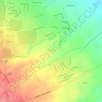
Name: Laguerta topographic map, elevation, terrain.
Location: Laguerta, Calamba, Laguna, Calabarzon, 4027, Philippines (14.16276 121.07416 14.18215 121.10073)
Average elevation: 633 ft
Minimum elevation: 453 ft
Maximum elevation: 794 ft
Thank you for supporting this site ❤️
Make a donation
Make a donation
Gear up for your next adventure:
As an Amazon Associate, this site earns from qualifying purchases at no extra cost to you.