Geolocate

Carolina topographic map

Click on the map to display elevation.

About this map

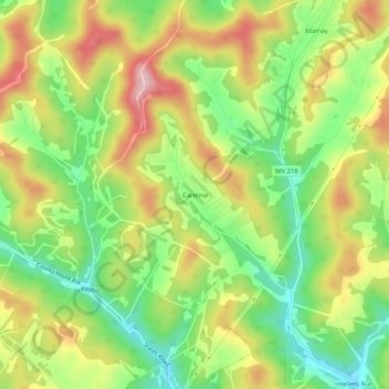
Name: Carolina topographic map, elevation, terrain.

Location: Carolina, Marion County, West Virginia, 26563, United States (39.46036 -80.29342 39.50036 -80.25342)

Average elevation: 1,243 ft

Minimum elevation: 912 ft

Maximum elevation: 1,634 ft

Marion County trails, hiking, mountain biking, running and outdoor activities

Other topographic maps

Click on a map to view its topography, its elevation and its terrain.

Morris Park

United States > West Virginia > Marion County > Fairmont

Average elevation: 1,132 ft

Mannington

United States > West Virginia > Marion County

Average elevation: 1,178 ft

Gear up for your next adventure:

🔭Telescopic Hiking Pole - Adjustable pole for hiking stability
🧭Compass with Lanyard - Easy‑carry compass for navigation
🦶Hiking Gaiters - Keep debris and water out of your boots
🗺️Topographic Maps - Detailed topo maps for hiking, exploring and outdoor navigation
🏫Relief Map Kits - Hands-on tools for teaching landforms and elevation

As an Amazon Associate, this site earns from qualifying purchases at no extra cost to you.