
Thank you for supporting this site ❤️
Make a donation
Make a donation
Gear up for your next adventure:
As an Amazon Associate, this site earns from qualifying purchases at no extra cost to you.
Larkhall topographic map
Click on the map to display elevation.
Thank you for supporting this site ❤️
Make a donation
Make a donation
Gear up for your next adventure:
As an Amazon Associate, this site earns from qualifying purchases at no extra cost to you.
About this map
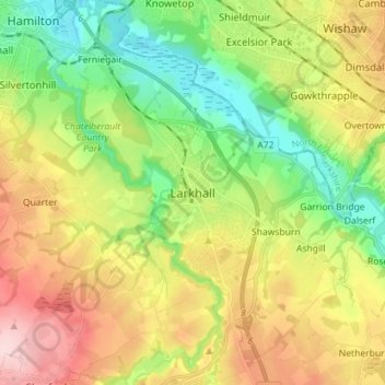
Name: Larkhall topographic map, elevation, terrain.
Location: Larkhall, South Lanarkshire, Scotland, ML9 1DR, United Kingdom (55.70011 -4.01461 55.78011 -3.93461)
Average elevation: 374 ft
Minimum elevation: 66 ft
Maximum elevation: 804 ft
Thank you for supporting this site ❤️
Make a donation
Make a donation
Gear up for your next adventure:
As an Amazon Associate, this site earns from qualifying purchases at no extra cost to you.