Geolocate

Ardmore topographic map

Click on the map to display elevation.

About this map

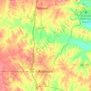
Name: Ardmore topographic map, elevation, terrain.

Location: Ardmore, Carter County, Oklahoma, United States (34.12886 -97.21288 34.33242 -96.99870)

Average elevation: 846 ft

Minimum elevation: 689 ft

Maximum elevation: 1,004 ft

Carter County trails, hiking, mountain biking, running and outdoor activities

Other topographic maps

Click on a map to view its topography, its elevation and its terrain.

Glenn

United States > Oklahoma > Carter County

Average elevation: 876 ft

Gear up for your next adventure:

🛌Ultralight Sleeping Bags - Compact down bags for cold nights in the wilderness
📡Handheld GPS Device - Reliable handheld GPS for outdoor navigation
📻Weather Alert Radios - Stay informed of storm risks while off-the-grid
🔥Fast-Boil Camping Stoves - Efficient cooking systems for quick trail meals
🗺️Topographic Maps - Detailed topo maps for hiking, exploring and outdoor navigation

As an Amazon Associate, this site earns from qualifying purchases at no extra cost to you.