Geolocate

Bagacay topographic map

Click on the map to display elevation.

About this map

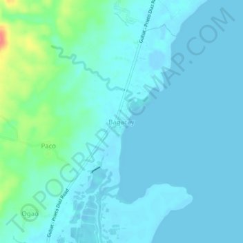
Name: Bagacay topographic map, elevation, terrain.

Location: Bagacay, Gubat, Sorsogon, Bicol Region, Philippines (12.96205 124.12150 13.00205 124.16150)

Average elevation: 30 ft

Minimum elevation: -30 ft

Maximum elevation: 210 ft

Gear up for your next adventure:

🏔️Mountain Trail Maps - High‑detail maps for popular peaks
🚪Portable Camp Chair - Foldable chair for comfort at camp
❄️Traction Cleats - Prevent slips on icy trails during winter hikes
🌧️Backpack Rain Cover - Keep gear dry in wet weather
🛰️Handheld GPS Units - Professional satellite navigators for precise backcountry mapping

As an Amazon Associate, this site earns from qualifying purchases at no extra cost to you.